File:2009-05-12 Zeyar 01.jpg
Jump to navigation
Jump to search

Size of this preview: 799 × 254 pixels. Other resolutions: 320 × 102 pixels | 640 × 203 pixels | 1,024 × 326 pixels | 1,280 × 407 pixels | 6,112 × 1,943 pixels.
Original file (6,112 × 1,943 pixels, file size: 4.75 MB, MIME type: image/jpeg)
Captions
Captions
Add a one-line explanation of what this file represents
| Description |
|
||
| Date | Taken on 12 May 2009, 08:46:44 | ||
| Source |
Own work of Simisa (talk · contribs)
|
||
| Author | Hansueli Krapf | ||
| Permission (Reusing this file) |
Attribution ShareAlike 3.0 |

|
| Camera location | | View this and other nearby images on: OpenStreetMap |
|---|
This file is licensed under the Creative Commons Attribution-Share Alike 3.0 Unported license.
- You are free:
- to share – to copy, distribute and transmit the work
- to remix – to adapt the work
- Under the following conditions:
- attribution – You must give appropriate credit, provide a link to the license, and indicate if changes were made. You may do so in any reasonable manner, but not in any way that suggests the licensor endorses you or your use.
- share alike – If you remix, transform, or build upon the material, you must distribute your contributions under the same or compatible license as the original.
| Annotations | This image is annotated: View the annotations at Commons |
File history
Click on a date/time to view the file as it appeared at that time.
| Date/Time | Thumbnail | Dimensions | User | Comment | |
|---|---|---|---|---|---|
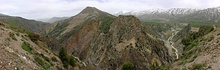
| current | 12:23, 12 July 2009 | 6,112 × 1,943 (4.75 MB) | Simisa (talk | contribs) | {{Information |Description={{IRN}}, Road from Tehran to the Caspian Sea near Zeyar |Source={{Own}} of {{User|Simisa}} {{Panorama|category=}} |Date=see metadata |Author=Hansueli Krapf |Permission=Attribution ShareAlike 3.0 |other_versions= |
You cannot overwrite this file.
File usage on Commons
There are no pages that use this file.
File usage on other wikis
The following other wikis use this file:
- Usage on fa.wikipedia.org
Metadata
Categories:
- Mount Damavand in 2009
- Views from Mount Damavand
- Rocks of Mount Damavand
- Flora of Mount Damavand
- Mount Doberar
- Mount Hamasun
- Road 77 (Iran)
- Haraz River
- Haraz Valley
- Bridges in Mazandaran Province
- Bridges over the Haraz River
- Trees in Mazandaran Province
- Snow in Mazandaran Province
- Clouds in Mazandaran Province
- Panoramics in the Alborz