File:14-46-35-f-mutzig.jpg

Original file (4,288 × 2,847 pixels, file size: 13.78 MB, MIME type: image/jpeg)
Captions
Captions
Summary[edit]
| Description |
This file was uploaded with Commonist. Dansk: Tunnel i Fort de Mutzig (tidligere Feste Kaiser Wilhelm II). Det tyske fort fra det 19. århundrede ligger nær Mutzig i Alsace, nu en del af Frankrig.
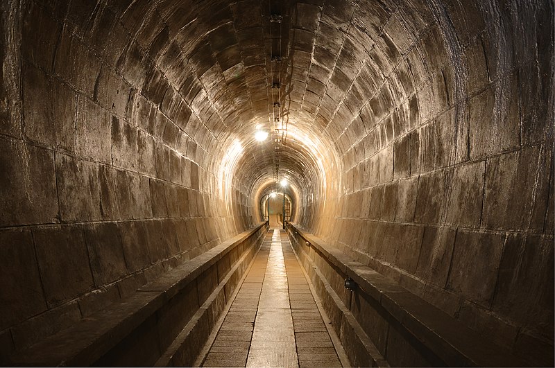
Deutsch: Feste Kaiser Wilhelm II (HDR), Mutzig, Elsass, Frankreich
English: Tunnel in Fort de Mutzig, France
Français : Tunnel dans le Fort de Mutzig, à Mutzig, Alsace, France |
||||||||||||||||||||||
| Date | |||||||||||||||||||||||
| Source | Feste Kaiser Wilhelm II | ||||||||||||||||||||||
| Author |
|
||||||||||||||||||||||

| Camera location | | View this and other nearby images on: OpenStreetMap |
|---|
|

This image was selected as picture of the day on Wikimedia Commons for 2 October 2010. It was captioned as follows: English: Tunnel in Fort de Mutzig (Feste Kaiser Wilhelm II). The 19th century German fort in Alsace is located near Mutzig (today : France). This is a tone-mapped HDR. Other languages:
Čeština: Tunel ve Fort de Mutzig, pevnosti v Alsasku (v dnešní Francii) postavené v 19. století Německem (tónově mapovaná HDR fotografie) Dansk: Tunnel i Fort de Mutzig (tidligere Feste Kaiser Wilhelm II). Det tyske fort fra det 19. århundrede ligger nær Mutzig i Alsace, nu en del af Frankrig. Deutsch: Feste Kaiser Wilhelm II (HDR), Mutzig, Elsass, Frankreich English: Tunnel in Fort de Mutzig (Feste Kaiser Wilhelm II). The 19th century German fort in Alsace is located near Mutzig (today : France). This is a tone-mapped HDR. Español: Túnel en el Fuerte Kaiser Guillermo II. El fuerte alsacio alemán del siglo XIX está situado cerca de Mutzig (actualmente Francia). Esta es una imagen HDR. Esperanto: Tunelo en la germana fuorto Imperiestro Vilhelmo la 2a de la 19a jarcento en Mutzig, nun en Francio.Tio estas HDR-kolor-plibonigita bildo Magyar: A mutzigi erőd alagútja; a németek által épített erőd ma Franciaország területén található Nederlands: Tunnel in de Feste Kaiser Wilhelm II bij Mutzig (nu Frankrijk), een van de forten die Duitsland (in 1893) bouwde om Straatsburg te verdedigen tegen de Fransen. Македонски: Тунел во тврдината „Кајзер Вилхелм II“ - германска тврдина во Алсас од XIX век близу Муциг (денес во Франција). Русский: Тоннель в форте де Мутциг. Форт XIX века в Эльзасе, расположенная около Мутцига (сейчас во Франции). Фотография выполнена в технике тонированной HDR. 日本語: Fort de Mutzig (Feste Kaiser Wilhelm II) のトンネル。現在はフランスに属するアルザスの Mutzig 近くにある、ドイツ時代の要塞である。トーンマッピングされたHDR画像。 中文: 法国阿尔萨斯马茨格城堡(德皇威廉二世)中的隧道 |
Licensing[edit]
- You are free:
- to share – to copy, distribute and transmit the work
- to remix – to adapt the work
- Under the following conditions:
- attribution – You must give appropriate credit, provide a link to the license, and indicate if changes were made. You may do so in any reasonable manner, but not in any way that suggests the licensor endorses you or your use.
| This image, originally posted to Flickr, was reviewed on 28 August 2019 by the administrator or reviewer Ibrahim.ID, who confirmed that it was available on Flickr under the stated license on that date. |
File history
Click on a date/time to view the file as it appeared at that time.
| Date/Time | Thumbnail | Dimensions | User | Comment | |
|---|---|---|---|---|---|
| current | 09:37, 27 July 2010 | | 4,288 × 2,847 (13.78 MB) | ComputerHotline (talk | contribs) |
You cannot overwrite this file.
File usage on Commons
The following 60 pages use this file:
- User:ComputerHotline/Archive 1
- User:ComputerHotline/Archive 2
- User:ComputerHotline/examples (3)
- User:Dronebogus/Favorites
- User:Jon Harald Søby/Liz
- User:Nlaylah/Favorites
- Commons:Featured picture candidates/File:14-46-35-f-mutzig.jpg
- Commons:Featured picture candidates/Log/August 2010
- Commons:Featured pictures/Places/Agriculture
- Commons:Featured pictures/Places/Architecture/Exteriors
- Commons:Featured pictures/Places/Architecture/Religious buildings
- Commons:Featured pictures/Places/Architecture/Transport
- Commons:Featured pictures/Places/Interiors
- Commons:Featured pictures/Places/Interiors/Religious buildings
- Commons:Featured pictures/Places/Interiors/Religious buildings/Ceilings
- Commons:Featured pictures/Places/Other
- Commons:Featured pictures/Places/Settlements
- Commons:Featured pictures/chronological/2010-B
- Commons:Files used on the AARoads Wiki/1
- Commons:Photo challenge/2017 - June - Vanishing Point
- Commons:Picture of the Year/2010/Galleries/Index/10
- Commons:Picture of the Year/2010/Galleries/Index/Interiors
- Commons:Picture of the Year/2010/Galleries/Interiors
- Commons:Picture of the Year/2010/Galleries/Interiors/Large
- Commons:Picture of the Year/2010/Galleries/Interiors/Small
- Commons:Picture of the Year/2010/Galleries/Table
- Commons:Picture of the Year/2010/Galleries/Table/08
- Commons:Picture of the Year/2010/R1/File:14-46-35-f-mutzig.jpg
- Commons:Picture of the Year/2010/Results/R1/ALL/Table
- Commons:Picture of the Year/2010/Results/R1/Interiors
- Commons:Picture of the Year/2010/Results/R1/Interiors/Table
- Commons:Potd/2010-10
- Commons:Potd/2010-10 (da)
- Commons:Potd/2010-10 (de)
- Commons:Potd/2010-10 (nl)
- Commons:Potd/2010-10 (pt)
- Commons:Quality images/Subject/Places/Man made structures/Buildings, Exterior/Part 1a
- Commons:Quality images candidates/Archives July 2010
- Commons talk:Photo challenge/themes/Archive
- Commons talk:Picture of the Year/2010/Galleries/Table
- Commons talk:Quality images/Subject/Places/Man made structures
- Template:Places FP galleries top
- Template:Potd/2010-10
- Template:Potd/2010-10-02
- Template:Potd/2010-10-02 (cs)
- Template:Potd/2010-10-02 (da)
- Template:Potd/2010-10-02 (de)
- Template:Potd/2010-10-02 (en)
- Template:Potd/2010-10-02 (eo)
- Template:Potd/2010-10-02 (es)
- Template:Potd/2010-10-02 (fr)
- Template:Potd/2010-10-02 (hu)
- Template:Potd/2010-10-02 (it)
- Template:Potd/2010-10-02 (ja)
- Template:Potd/2010-10-02 (mk)
- Template:Potd/2010-10-02 (nl)
- Template:Potd/2010-10-02 (pt)
- Template:Potd/2010-10-02 (ru)
- Template:Potd/2010-10-02 (zh-hans)
- Template:Potd/2010-10 (zh-hans)
File usage on other wikis
The following other wikis use this file:
- Usage on be-tarask.wikipedia.org
- Usage on bh.wikipedia.org
- Usage on bn.wikipedia.org
- Usage on ceb.wikipedia.org
- Usage on crh.wikipedia.org
- Usage on cv.wikipedia.org
- Usage on de.wikipedia.org
- Usage on en.wikipedia.org
- Usage on eo.wikipedia.org
- Usage on fa.wikipedia.org
- Usage on fr.wikipedia.org
- Usage on hu.wikipedia.org
- Usage on id.wikipedia.org
- Usage on kn.wikipedia.org
- Usage on ko.wikipedia.org
- Usage on lbe.wikipedia.org
- Usage on mk.wikipedia.org
- Usage on os.wikipedia.org
- Usage on pl.wikipedia.org
- Usage on pt.wikipedia.org
- Usage on ru.wikipedia.org
- Usage on ru.wikinews.org
- Usage on sah.wikipedia.org
- Usage on sq.wikipedia.org
View more global usage of this file.